trail's end
Originally uploaded by wereldmuis.
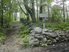
After passing over Mt Watatic, the end of the trail had to be near. Eventually I came to this confusing sign. It reads:
← Wapack Trail →
Mt Watatic ←1.2
MA. Rt. 119 ← 2.4
N.H. Rt 123/124 → 4-4.5
And there's a little sign pointing back towards Nutting Hill, too.
There are blue blazes running along the wall to the north.
And there is no mention of the Midstate Trail whatsoever.
So I sat there on the wall for a minute trying to figure out what to do. If this was the end of the trail, why wasn't there a sign saying so? And where were the two monuments described in the guide book?
My brain was fried and I missed the clue in the trail guide about the state boundary being marked by blue blazes. I wasn't expecting big neon lights flashing the words "You are now leaving MA, welcome to NH", but some sign that I was crossing the border was expected... So I kept going! I followed the damned yellow triangles for another 15 minutes before deciding that this corner must have been the boundary to NH.
I knew that the yellow triangles are used to mark the Wapack Trail in this area, as well, I just didn't realize that the Wapack Trail continues on into NH. Live and learn.
So I spent another 15 minutes trudging back (uphill, of course) to this stone wall corner. I re-read the guide book, and went 200 ft west of this point to look for the "original terminus monument." I found something, but I'm not sure that it was the terminus monument.
And then, given that it was 4:30 pm, I decided to take the shortcut back to the parking lot, rather than reverse tracks and go back over Watatic. Wise move! I probably saved about 45 minutes or so going that way.
No comments:
Post a Comment