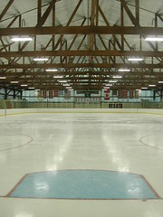
skating rink
Originally uploaded by wereldmuis.
I took my first ice skating lesson today. I only fell once! My sketchy rollerblading skills came back to me after about 10 minutes on the ice.
I took my first ice skating lesson today. I only fell once! My sketchy rollerblading skills came back to me after about 10 minutes on the ice.

Soon, I left Moosilauke's summit and decided that I had time to do a loop back to the car.
As it turned out, I was cutting it close. Moosilauke Carriage Rd is a very easy trip all the way to Hurricane Trail. It's wide, not too steep, and has some nice views on the way down.
But Hurricane Trail was a mess. The 800 ft climb from Moosilauke Carriage Rd to the summit was a river, with lots of deep puddles that needed to be navigated with care. That made the going very slow. I think it took over an hour to do about 1.6 miles here. It didn't help that I was tired from the Moosilauke climb already.
I hit the saddle near Hurricane Mtn at around 4 pm. I was already worried that I'd be coming out in darkness, so I made my way down the trail as quickly as possible. This half of the trail was still wet, but not nearly as bad as the other side.
I made it out at 5 pm, and there was still plenty of light, so I got lucky there. Not much room for error. Overall, though, it was a great day!
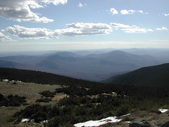
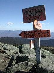
This is a view from the summit of Mt Moosilauke. Words can't describe this mountain. 360 degrees of great views. Wow!
I was lucky and got to spend 20 minutes wandering around at the top inspecting the area. I had the place totally to myself. There are a lot of cairns, multiple rock shelters, two plaques, a geodetic survey marker, and a lot of engravings in the boulders.
The temperature must have been around 50 °F up here, but I put on a light jacket because the wind was blowing so hard. Any snow that accumulated over the last couple weeks was almost gone. The trails were clear of ice and snow.
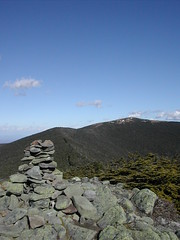
It's worth it to take the spur trail over to South Peak, only 0.2 miles off the Glencliff Trail. There are amazing views from South Peak in practically every direction.
You can see the trail up to Mt Moosilauke in this photo. It's an unbelievably easy stroll over to the peak from here. Of course, I did have great weather, which helped!
It took me 2 h 15 minutes to hike from the Glencliff trailhead to the junction with Moosilauke Carriage Rd. That's 3 miles, up 3000 ft. The AMC Guide estimates it as a 3 hour trip, so I did incredibly well up this part of the trip.
It really helps to have a clean, dry trail without a lot of obstacles.
Today's hike: 6 h 15 min | 11.2 mi | 1.8 mph
I took the Glencliff Trail to Mt Moosilauke (at 4802 ft), an elevation gain of 3300 ft. This was my 13th 4000-footer.
On the way back, I made a loop of it by taking Moosilauke Carriage Rd and then following Hurricane Trail back to the Glencliff Trail. Hurricane Trail takes you up another 900 feet.
The Glencliff Trail up to the junction with Moosilauke Carriage Rd is among the easier trails I've taken up a 4000-footer. It helped that the trail was fairly dry, with no ice or snow; in fact the weather was spectacular!
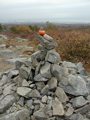
It turned out cold and gray this morning, so I decided to skip the Whites and go for a shorter hike closer to home. I spent about 1.5 hours over at Blue Hills Reservation instead.
Someone had propped a miniature pumpkin at the cairn on Buck Hill. Nice seasonal touch.
It was strangely busy at the park today. I guess the leaf peepers are still out.
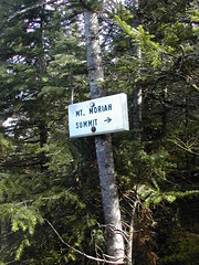
Mt Moriah is my twelfth 4000-footer in NH. I was a bit disappointed that it was so windy, and I was expecting more sun, too. I hope there's time for another hike or two before ice sets in. I saw a few flakes of ice on the descent from Mt Moriah.
Eventually, the Carter Moriah trail became less "slide"-y and more like a normal walk through the woods. It was around here I became a little nervous, since I heard 1) the sound of crowds screaming in the distance and 2) what sounded like gunshots. Briefly I imagined disaster. However, I decided that the screaming was probably coming from a ball game at the park I had passed along Rt 16. And the gunshots, well, that could be from hunters. I had stupidly forgotten to check for the opening of hunting season and was wearing all black with no hunter orange. I pondered the idea of my body being discovered in the woods, shot by a drunken hunter who had mistaken me for a bear.
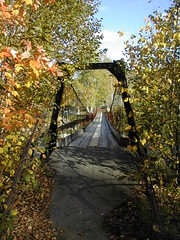
Finally, I hit Bangor St. Just a short walk away, I was filled with joy at the sight of a footbridge crossing the Peabody River. This meant I didn't have to walk all the way through town, and cut about a mile off the trip back to the car. Sweet!
The footbridge is marked as a line on the topo map, but the line is not labeled. I didn't realize that's what it was till I saw it in real life.

Once I reached Mt Moriah, I decided to continue on the Moriah Carter Trail, go down to Gorham, and walk the road to get back to the car. It would add miles to the trip, but I thought I'd be out of the wind more quickly.
Well, it turns out that Moriah Carter is a pretty difficult trail to go down here; this is not mentioned in the AMC Guide, and you can't tell it from the topo map either. Basically, there's about a mile or so of "slide"-like rock between Mt Moriah and Mt Surprise. Some parts are very close to vertical. I was very glad that I was only carrying about 10 lbs at this point.
So the going was really pretty slow again. Eventually, I reached the vicinity of Mt Surprise. I could see Gorham in the distance, and I could see the bridge close to where my car was parked on Rt 16, almost directly west from me. I briefly considered bushwhacking down to my car to save me the trek through town once I hit the road, but quickly decided that would be unwise, given the time of day.
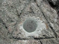
This is the second geodetic survey marker that I found on Moriah. I thought they were supposed to come in threes, but I think I've only ever seen them in pairs or singles.
This one reads "triangulation station" in addition to all the usual regulatory verbiage ("$250 fine or imprisonment for disturbing...").
The views from Moriah, and along the Carter Moriah trail, are spectacular. I didn't enjoy them much, though, due to the constant heavy winds.
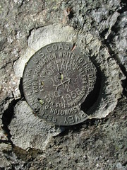
Once the high winds started, I wasn't enjoying the hike very much and just wanted to get up and get down. I hit the peak and was met with more blasting winds. And a surprise - I found two geodetic survey markers on Mt Moriah! Very nice!
As I neared the end of the Stony Brook Trail, strong winds began to pick up. They blasted the mountain top the entire time I was on it.
It is 1.4 miles from where Stony Brook Trail meets Carter Moriah until you get to Mt Moriah, just under a thousand feet of climbing. There are several sections which are completely exposed. The wind was almost strong enough to knock me off my feet. I think I wound up doing about 1.5 mph here.
It was very nice to finally reach the summit. There is a crazy clamber to get to the peak. It's the kind of thing that's fun when you're not carrying anything, a bit difficult with a light pack, and nasty if loaded up with a heavy pack.

As I moved up the Stony Brook trail, nearing the point where it meets Carter Moriah, I began noticing some wet bootprints on the rocks. Eventually I saw a couple of hikers up ahead. I stopped to fill my water bottle, and give them some distance.
Soon, I began to approach them again, and I realized I'd just have to pass them. They politely gave me the right of way.
Later on I caught up with them at the trailhead. They were kicking back at their car, downing some cold ones.
I had taken the loop back to the car, while they had apparently come back down via Stony Brook. They expressed some surprise at how fast I was hiking. It's my feeling that they were slow, not that I was fast - I wasn't going much faster than book time. It was somewhat amusing. I'm not used to people remarking on my speed (unless I'm being too slow). I didn't explain that to them though!
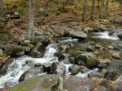
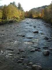
Climbing the Stony Brook Trail was overall pretty easy. The trickiest part was crossing Stony Brook.
I wasn't completely sure that I was supposed to cross here, in fact, since the trail is not well marked on the ascending side. Arriving here, I wondered if this was just a side trail, since I didn't see any blaze, carin or other marking on either side of the brook that made it clear the trail continued on the other side.
I've erroneously crossed streams in the past, and I didn't want to make that mistake now. The brook was really full, and crossing it was a puzzle. I spent 10 or 20 minutes walking up and down it looking for a way to cross without removing my boots. In the end, I caved in and crossed barefoot. This photograph shows the path I took across the rocks, just above the little cascade. Fortunately the water wasn't icy cold. My feet dried off quickly and I was soon ready to travel on.
There's an arrow engraved in a sign on the other side of the brook which you can only see once you're across. Very helpful - NOT! It should be moved so it's visible from both sides of the trail.
Yesterday's hike: 6 h 30 min | 11 mi | 1.7 mph
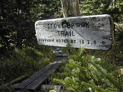
I took the Stony Brook Trail up to Carter Moriah Trail, turned north and followed Carter Moriah over Mt Moriah and down into the town of Gorham to make it a loop.
The Stony Brook trailhead is easy to find, where Rt 16 crosses the Peabody River. To begin with, I wasn't sure whether I would do the loop, but kept it open as an option.

