Wednesday, May 30, 2007

Deer at Sleeping Giant


Deer at Sleeping Giant
Originally uploaded by wereldmuis.


Today I spotted several deer along the trails at Sleeping Giant, including a deer with her fawn. This particular deer didn't appear to be too alarmed by my presence.

I also saw a turkey, and the woods were alive with chipmunks and squirrels.

Sleeping Giant view


View from an unmarked trail
Originally uploaded by wereldmuis.


Another nice hike today! This is a view from an unmarked trail on the Giant.

Tuesday, May 29, 2007

View from Hezekiah's Knob


View from Hezekiah's Knob
Originally uploaded by wereldmuis.

Wonderful hiking weather today, maybe a little hot but not very humid.

Sunday, May 27, 2007

Aim high

PowerBall

My brother gave me a Dyna-Flex PowerBall last year, but I haven’t used it much, for no good reason. Who wouldn’t want to work with this thing? It’ll give you fingers of steel, and you’ll be climbing walls like Spidey in no time.

Yesterday, I started playing with it again. I’m getting it up to just about 6000 RPM. Is 10K RPM out of reach? Maybe, but I hope not!

Saturday, May 26, 2007

Fortune cookie

No man will work for your interests unless they are his
You can say that again!

May - Confessions of a Street Addict

I just finished reading "Confessions of a Street Addict" by James J. Cramer.

This book is a good counterpoint to Nicholas Maier’s Trading with the Enemy (which I read last March). It is well-written, very detailed, and portrays Cramer in a more even-tempered way. He may throw bottled drinks at his employees and make them wear post-its on their foreheads, but when you get the story from the horse’s mouth, it doesn’t seem like he’s that bad of a guy. And even as he’s busy making everyone surrounding him miserable, there’s no one in the place more miserable than he is, himself. The reporting of his aggravation at the revolving management at TheStreet.com is worth the price of the book.

We are also treated to various nuggets of market wisdom. For example:

On the dot-com craze, p. 238-239:

The public, with high job growth, and lots of 401(k) money to put to work, needed stock to invest in.... Put simply, there wasn't enough public equity to go around, particularly dotcom paper, to equal all of the cash looking for a home.

And further on p. 304:

Major companies, valued in the billions of dollars, visited my office and when closely questioned knew nothing about their own business or the way analysts categorized them. Anything went. Capitalism unbounded and unrestrained.

Yes, quotes like these, coupled with his own stories of what seem a lot like market manipulation to my naive ears, make me want to put all of my cash into government bonds. Oh wait, they're crooks too.

Thursday, May 24, 2007

High water


High water
Originally uploaded by wereldmuis.


Today's hike: 2 h | 4.8 mi | 2.4 mph

I went for a hike along the Quinnipiac Trail, starting at Chestnut Lane in Sleeping Giant Park and hiking down to Quinnipiac River State Park.

According to The Connecticut Walk Book West, p 223, "parts of the trail are overgrown with brambles and poison ivy that can be impenetrable during late spring and summer when growth is lush." You can say that again! I'm not allergic to poison ivy (knock on wood), or I never would have attempted this section - it is loaded with that plant. On top of that, trees have fallen over, blocking the path, and there are sections of the trail where you really could use a machete. I'm going to have to do a thorough tick inspection.

After hiking for about 30 minutes south of Toelles Rd, I came to this deep stream (could this be Pine Brook? There's supposed to be a bridge at Pine Brook). I didn't see any way around it, so I turned around. I was hoping to complete the Quinnipiac Trail today, but it'll have to wait.

Pink lady's-slippers


Pink lady's-slippers
Originally uploaded by wereldmuis.

These pink lady's-slippers are currently in bloom at Sleeping Giant. They're on the yellow trail, very close to where the blue trail crosses it, just off Chestnut Lane.

Am I the only one who finds these flowers a bit, uh, suggestive?

Wednesday, May 23, 2007

Shrimp fried rice

In my experience, the Chinese takeouts in suburbia serve some pretty unappealing stuff. This shrimp fried rice is an example of the weirdness: Where's the egg? Isn't fried rice supposed to contain egg? And why does it look all orangey-yellow, as if someone snuck in some saffron (or yellow #5)?

I can't complain too much, because the shrimp was cooked to perfection. I also got some broccoli with garlic sauce, which was tolerable - the broccoli was not overcooked, still bright green, but the sauce was too oily and insufficiently hot and spicy.
Posted by Picasa

Monday, May 21, 2007

Tank eight

Eighth fill up yesterday. Total miles: 2803. Trip miles: 414.5. Gallons: 8.77. Price per gallon: $3.279. This was at a Hess station on Long Island.

Screen mileage: 54.0 mpg. Tank mileage: 47.2 mpg. Can't explain the difference here.

Lots of highway miles. One ugly traffic jam.

Monday, May 14, 2007

Tank seven

Seventh fill-up yesterday. Total miles: 2388. Trip miles: 410.4. Gallons: 7.843. Price per gallon: $3.139.

Screen mileage: 53.8 mpg. Tank mileage: 52.3 mpg. Same as last time!

Most of the mileage was done on highway trips, 55 to 65 mph. Lots of family events going on, so I'm driving all over creation.

Sunday, May 13, 2007

Tynan Park connector


Tynan Park detour
Originally uploaded by wereldmuis.


This is where the new Tynan Park connector comes in. It is at the north end of the Higby Mountain section of the Mattabesett, as you approach Country Club Rd.

I kept following the blue blazes, rather than going to Tynan Park, because I was curious about the state of the main trail. At this time, it's a bit rutted, messy, and muddy, with trees sometimes blocking the trails. Presumably this is blowdown, but maybe it's due to logging activity.

You can see evidence that a tractor has been through this area; the woods road has deep ruts that couldn't have been made by an ATV. And indeed once you get to Country Club Rd, you find the tractor itself.

Black Pond


Black Pond
Originally uploaded by wereldmuis.


Yesterday's hike: 3 h 25 min | 8.2 mi | 2.4 mph

I did the Higby Mountain section of the Mattabesett, starting from the parking lot on Rt 66 and going all the way to the Country Club Rd exit and back. I did this section last August, from the opposite direction.

Although the view was a bit hazy, the afternoon was cool, perfect for hiking. I pushed myself to get through the entire section as quickly as I could because I didn't really have as much time as I needed.

In the foreground here is Cockaponset State Forest, with a glimpse of Black Pond in the back, beyond Rt 66.

Thursday, May 10, 2007

Cherry trees


Cherry trees
Originally uploaded by wereldmuis.

It was a gray morning, threatening rain. I took this photo along one of the main streets in my town. A few of the streets are lined with cherry trees, which put up a pretty display every spring. They're starting to fade now.

Actually, I'm not completely sure that they are cherry trees, but I think they are.

Wednesday, May 09, 2007

Mattabesett is open to hikers

Recently I posted about some no-trespassing signs at the Country Club Rd entrance to the Mattabesett trail. I contacted the CFPA and got a reply from Theresa Peters, who gave me the good news: the trail is open to hikers. Here's what she said:
Actually, the City of Middletown was (overzealously) posting the signs to ward off ATV riders. Unfortunately, the wording of the signs also scares the hikers. Hiking is allowed, the blazes in that area have been refreshed.
...
As a general rule, when a trail is closed to hikers, the blazes get blacked out with black paint and Trail Closed signs get posted and our website will have a trail closure notice on it.
She mentioned that there's a new connector trail in the area:
This spring, a new connector trail opened that links Tynan Park (on Higby Road) to the Mattabesett Trail. It is more scenic to park at Tynan Park and take the blue/red connector trail and link to the Mattabesett Trail that way, than it is to park at Country Club Road and use the section to the south which is not so scenic (ATV ruts and illegal dumping).
Thanks for this info and the rapid response, Theresa! I'm very glad that the trail is still open, and I'll try the Tynan Park connector next time I'm in the area.

Sunday, May 06, 2007

Tank six

Sixth fill-up yesterday. Total miles: 1978. Trip miles: 364.6. Gallons: 6.906. Price per gallon: $3.109.

Screen mileage: 52.8 mpg. Tank mileage: 52.3 mpg.

Note that I filled up at a different from usual gas station so the tank measurements could be off.

I think well over half the mileage was done on highway trips, between 55 and 65 mph.

Chauncey Peak

Fortunately, I was more interested in hiking up to Chauncey Peak, at the other end of Country Club Rd, and I could avoid any questions of trespassing.

As usual, I stopped by for a look at the old engravings on the cliffs overlooking the quarry. I was disturbed to find that some of them have been newly defaced by some moron with a can of spray paint. In particular, my favorite engraving, done by the Cosmopolitan Club in 1875, has been partially obscured. Hopefully the paint will fade quickly. While it's true that the engravings are, in some sense, a form of graffiti themselves, they now wear the patina of history, which gives them special status. Well, unless they're fake, of course. I'd love to find some verification that the engravings are genuine.

Crescent Lake
View of Crescent Lake aka Bradley Hubbard Reservoir

Mattabesett

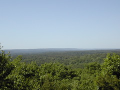
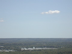
Nice day for a hike, if a bit windy.

Billy pointed out that there are now no-trespassing signs posted by the city at the entrance to the Mattabesett trail, off Country Club Rd. I had to go check it out.

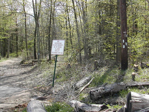
Indeed, there are now a couple of big old signs that read "NO TRESPASSING PRIVATE PROPERTY NO ATV RIDING ALLOWED PER CITY ORDINANCE 285-22". Apparently this is a reference to Middletown ordinance 285-22 [PDF], forbidding the use of motor scooters and the like on public property. I don't understand the application of that particular ordinance here, because so far as I can tell, the ordinance has to do with public property, whereas the sign says this is private property.

No trespassing.

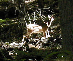
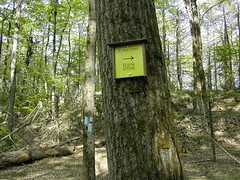
Aside from that quibble, the sign is confusing and annoying for anyone coming in on foot. Does "no trespassing" apply only to motorized vehicles, or is the blue trail itself blocked here? There are new blue blazes in the immediate vicinity of the no trespassing signs; you can see them in this photo. The signs were not there last summer, and I'm pretty sure that at least some of the blue blazes are new, too.

This requires further investigation.