Total miles: 35801. Trip miles: 408.0. Gallons: 6.689. Price per gallon: $2.619.
Screen mileage: 55.6 mpg. Tank mileage: 61.0 mpg.
All highway miles.
Sunday, November 29, 2009
Thursday, November 26, 2009
Tank ninety-nine
Total miles: 35393. Trip miles: 212.6. Gallons: 3.981. Price per gallon: $2.679.
Screen mileage: 54.1 mpg. Tank mileage: 53.4 mpg.
Screen mileage: 54.1 mpg. Tank mileage: 53.4 mpg.
Wednesday, November 25, 2009
November 2009 - The Girl Who Played with Fire

The Girl Who Played with Fire is an excellent follow-up to The Girl with the Dragon Tattoo. It’s another page turner, just as addictive as the first book in the series. Stieg Larsson had a real talent for writing thrillers!
See more progress on: Read one book a month
Monday, November 23, 2009
gloomy day
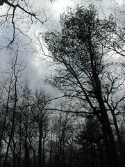
gloomy day
Originally uploaded by wereldmuis.
The day felt bleak and wintery, although it wasn't very cold.
autumn pine cones
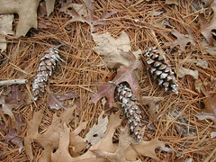
autumn pine cones
Originally uploaded by wereldmuis.
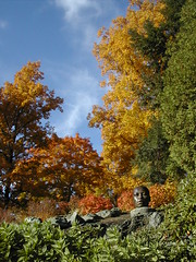
I took a short hike at Blue Hills Reservation yesterday. Most of the leaves are down.
Sunday, November 22, 2009
Tank ninety-eight
Total miles: 35181. Trip miles: 222.3. Gallons: 5.32. Price per gallon: $2.599.
Screen mileage: 50.2 mpg. Tank mileage: 41.7 mpg.
Short commutes. Terrible tank mileage!
Screen mileage: 50.2 mpg. Tank mileage: 41.7 mpg.
Short commutes. Terrible tank mileage!
Wednesday, November 11, 2009
back to parking lot
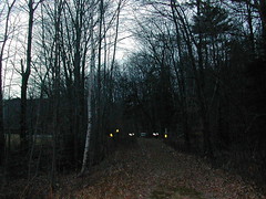
back to parking lot
Originally uploaded by wereldmuis.
After I hit Old Mast Road, I only had one mishap. There's also a dirt road that diverges from Old Mast Road, and I managed to wander onto that. No harm, I wound up at the parking lot just the same. The dirt road is not described well in the AMC Guide, but you can see it on the map (Map #3, which comes with the Guide).
Speeding along, I was surprised when I suddenly saw my car up ahead. From looking at the trail map, I thought that I would need to do some walking along Ferncroft Rd to get from the Old Mast Road back to the Dicey's Mill trailhead. But it turns out that the two trailheads are at opposite ends of the Ferncroft Rd parking lot.
It was a pleasant surprise to make it back out at 4:30 pm, just around sunset. This photo actually makes it look a lot darker than it was.
I cut things close by taking an alternate route, but I'm still glad I did it. It's just more fun doing a loop and seeing different things on the way back. Too bad there's so little daylight this time of the year!
I discovered when I got home that I'd lost some skin on my heel, where the blister cushions had rubbed off - haven't had that happen before. I'm still feeling pretty sore today, but incredibly good nevertheless. There should be more days like this!
Entire Mt Passaconaway Trip Report
steep drop along walden trail
steep drop walden trail
Originally uploaded by wereldmuis.
As I traveled along the Walden Trail, I kept coming to one incredibly steep drop after another. After about an hour of travel, I convinced myself that I was, in fact, no longer on the Walden Trail; that I'd somehow missed the junction with the Wonalancet Range, and was now traveling along that.
However, I was wrong. When I finally hit the clearly marked junction to the Wonalancet Range Trail, it was about 3 pm. I must have been doing less than 1 mph on the descent from the summit!
Following the Wonalancet back down to the parking lot appeared to be tempting fate - 3.2 miles back from this junction, including a minor summit. Instead, I could continue another 0.9 miles on the Walden Trail till it hit the Old Mast Road at a 4-way junction, and follow that back another 2 miles to the parking lot. Old Mast is basically a logging road, with a light downhill grade, so it would be fairly easy to follow if it started to get dark before I got back. Pancakes being the better part of valor, I immediately switched plans accordingly.
True to its nature, Walden continued to throw some very steep droppages at me before I finally hit the junction. I admit that there was a little cursing to be heard in the wilderness, that day.
Entire Mt Passaconaway Trip Report
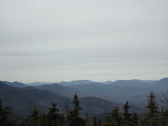
walden trail view
walden trail view
Originally uploaded by wereldmuis.
The AMC Guide (p 408) is pretty clear about the Walden Trail. There has been work done on it, but it's still incredibly steep and rough in spots. Nevertheless, I heavily underestimated it!
Entire Mt Passaconaway Trip Report
summit of Mt Passaconaway
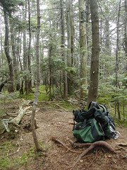
summit of Mt Passaconaway
Originally uploaded by wereldmuis.
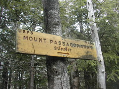
Right after the overlook, you come to a sign pointing to the summit of Mt Passaconaway, off to the right on a spur trail. I followed this to a fork; both branches of the fork petered out after a few meters. This spot on the left fork looked the highest, to me; I'm guessing it's the true summit.
At this point I was feeling pretty good. It was 1 pm; I'd made the ascent in good time, despite delays, and I knew that if I just returned the same way I'd come, I'd probably be out in two or three hours. But what fun is that? There are several other ways off of Passaconaway, all heading back towards the parking lot... so why not do a loop?
I studied the Guide quickly for an alternate route, and decided to try the Wonalancet Range Trail (p 409). To get there, I'd need to follow the Walden Trail down off the mountaintop, which I proceeded to do apace.
Entire Mt Passaconaway Trip Report
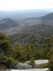
view from Mt Passaconaway
view
Originally uploaded by wereldmuis.
There's a lovely view near the summit of Mt Passaconaway. Even though it was a cloudy day, I still had a nice look out at mountains in the distance.
Entire Mt Passaconaway Trip Report
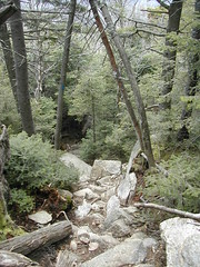
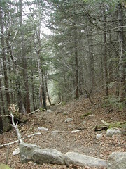
bouldery trail
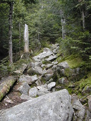
bouldery trail
Originally uploaded by wereldmuis.
Here we are at the toughest part of Dicey's Mill Trail - the two-tenths of a mile of boulder clambering just below the summit. It's not at all difficult compared to the approach to East Osceola from the Kanc. Just be prepared to use hands and feet to get over it.
Entire Mt Passaconaway Trip Report
view down dicey's mill trail
view down trail
Originally uploaded by wereldmuis.
This is a view back down Dicey's Mill Trail just at the intersection with the Rollins Trail at 3.9 miles. So far so good, the ascent has been nice and gradual.
The Dicey's Mill Trail approach to Passaconaway is reminiscent of the Mt Tecumseh Trail approach to Tecumseh (probably the same whether you're going via Tripoli Rd or Waterville Valley Ski Area), which I've also done recently. It's really a pretty sweet trail. It leads you on pretty level ground for the first couple of miles, and then there's a gradual, steady ascent at a pretty bearable grade.
And then, you hit the part where you're climbing over boulders near the top. There's a lot more boulder climbing here than there is on Tecumseh.
Entire Mt Passaconaway Trip Report
dicey's mill boulder
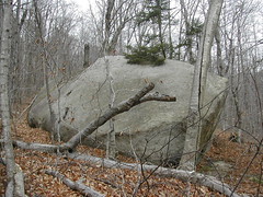
dicey's mill boulder
Originally uploaded by wereldmuis.
This is the giant whale of a boulder near where Dicey's Mill trail crosses the Wonalancet River at 2.3 miles. Supposedly there are remains of the mill in the area. Unfortunately, I was too hurried at this point to seek them out. I'd like to come back some day for another look.
Entire Mt Passaconaway Trip Report
tom wiggin trail
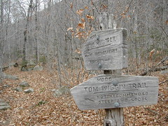
tom wiggin trail
Originally uploaded by wereldmuis.
Dicey's Mill Trail meets the Tom Wiggin Trail at 1.9 miles. At this point I was thinking "yeesh, I'm going incredibly slow, and there's hardly been any elevation gain yet!"
You can take the Tom Wiggin Trail up to Mt Whiteface, another 4000-footer. In the back of my mind, I had been thinking about attempting Mt Whiteface on the way back, although I knew it would be tough getting out before sunset if I took that route.
The sign says that Tom Wiggin Trail is "not recommended steep and loose". The Guide says the same thing (p 416 - "...many sections of loose, gravelly footing that are particularly tedious on the descent"!). In the end I decided not to risk it. Mt Whiteface will get its own separate day!
Entire Mt Passaconaway Trip Report
blue blazes
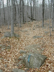
blue blazes
Originally uploaded by wereldmuis.
Dicey's Mill trail is pretty well marked, with blue blazes along most of the way, and signs at trail junctions. Despite that, I managed to lose the trail about a half mile after entering the Sandwich Range Wilderness. I zigged when I should have zagged, and the trail just vanished! I thought I had missed a bend in the trail, and backtracked all the way back to the entrance to the Wilderness area, wondering whether my chances at summitting Passaconaway were blown by this little diversion.
It turned out that I had followed the trail correctly, and I should have just gone right instead of left at the point where I'd become confused. It was pretty easy to see when I came back to it, but there were no blue blazes at that point to help.
Later, after about an hour of hiking, I had to stop to apply extra blister cushions to my heels. I had started out with a couple to begin with, but it felt like they weren't helping, so I added two more (in the end these didn't help as much as they had in the past).
With these delays, I was not off to a promising start, time-wise! Despite that, I was really enjoying the hike.
Entire Mt Passaconaway Trip Report
entering sandwich range wilderness
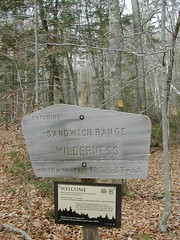
entering sandwich range wilderness
Originally uploaded by wereldmuis.
Very soon after leaving the houses behind, you enter the Sandwich Range Wilderness. The boundary is clearly announced. First, there's this rustic wooden sign which reads "Entering Sandwich Range Wilderness White Mountain National Forest". Then there are two "bearing trees", marked with small yellow signs. Finally, there's a "land survey monument", which looks a bit like a giant nail with a head the size of my palm, surrounded by rocks that are spray-painted neon red. This last item has its own separate sign.
Up until this point at 0.8 miles, the trail is very tame and level. Beyond the signs, the trail begins to rise a bit.
Entire Mt Passaconaway Trip Report
no trespassing with bear dogs
no trespassing with bear dogs
Originally uploaded by wereldmuis.
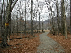
I left the parking lot at 9 am. The AMC White Mountain Guide says that reaching the summit is expected to take 3 h 45 min (p 407). At worst, I expected the round trip to take 7 hours or so, which would mean little time for dawdling or getting lost if I wanted to make it out of the woods before sunset.
The Guide is actually pretty clear about how Dicey's Mill starts - you have to go through some private property first. Still, it's kind of weird to hike straight on past signs that say "No Trespassing", even if they are qualified with the words "With Bear Dogs" as these signs were. I'm guessing a bear dog is a dog that is trained to hunt bears in some way... presumably the signs are not referencing amphicyonids, but you never know.
In any case, I trooped on through, past the signs, past the house where some guys were working on the roof (oops, guess I did meet some people while hiking!), and off into the Sandwich Range Wilderness.
Entire Mt Passaconaway Trip Report
dicey's mill trailhead
dicey's mill trailhead
Originally uploaded by wereldmuis.
Here we are at the trailhead.
Dicey's Mill shares the trailhead with a number of other trails, many of them leading to Passaconaway in one way or another. The trails branch off from the parking area in two directions. I was in a hurry to get started, so I didn't check out the trailhead signs at the opposite side of the parking lot... which would have been useful, later on.
This is a very nice trailhead, with a lot of parking available (I'd guess there's room for about 20 cars). There's even a port-a-john at one end. What more can you ask for?
On this day, I only saw one other car in the lot when I started out, and there were two different cars there when I departed. Thus it was no surprise that I didn't meet a single person during the entire hike - sweet!
Entire Mt Passaconaway Trip Report
mt passaconaway - fourth 4000-footer
nearing the summit
Originally uploaded by wereldmuis.
Yesterday's hike: 5 h 50 min | 9 mi | 1.5 mph. The mileage doesn't count some backtracking that I did when I got slightly lost, or side trips, so my pace was probably better than reported. Also, I was carrying my backpack, weighing about 15 lbs or so.
The weather had been so temperate for the last few days that I decided to take a swing at another 4000-footer. I played hookie to do that yesterday. Even with the recent good weather, there still might be ice in the mountains... and without traction devices, I wanted to be as sure as possible that I wouldn't encounter significant ice. Some reports at Views from the Top indicated that south facing trails were in good shape, possibly because they get more sun this time of year, so I focused on those.
My choices were narrowed down also by the amount of time I had. With less daylight at this time of the year, I needed a route to a summit that was short enough that I could cover the round trip in six or seven hours. I finally decided to try climbing Mt Passaconaway from the south, via the Dicey's Mill Trail. It's 4.6 miles to the summit, with an elevation gain of 2950 feet, and reported to be a relatively easy climb.
Entire Mt Passaconaway Trip Report
Tuesday, November 10, 2009
Tank ninety-seven
Total miles: 34958. Trip miles: 274.1. Gallons: 5.053. Price per gallon: $2.579.
Screen mileage: 51.5 mpg. Tank mileage: 54.2 mpg.
One 140 mile drive, otherwise short commutes.
Screen mileage: 51.5 mpg. Tank mileage: 54.2 mpg.
One 140 mile drive, otherwise short commutes.
Saturday, November 07, 2009
granary burial ground
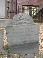
granary burial ground
Originally uploaded by wereldmuis.
We took a walk along part of the Freedom Trail. There are several old cemeteries along the trail, in which rest some historically important people. This is a tombstone at the Granary Burial Ground. The tombstones here are really neat, many of them engraved with skulls of some sort.
cemetery on boston common
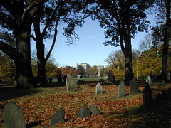
cemetery on boston common
Originally uploaded by wereldmuis.
In keeping with the Halloween theme, we visited some cemeteries in Boston on Sunday. This is the Central Burying Ground on Boston Common.
drum column
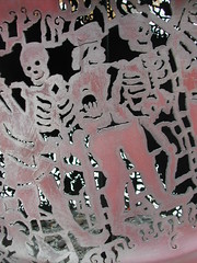
drum column by cal lane - detail
Originally uploaded by wereldmuis.
This sculpture by Cal Lane has some fun Halloween-ish details.
eternal presence by john wilson
eternal presence by john wilson
Originally uploaded by wereldmuis.
Last weekend - Halloween - my sister came for a visit. We went over to the DeCordova sculpture garden. The weather was fantastic, nice and warm, except for some insanely blustery winds.
Thursday, November 05, 2009
A review of "The Golden City: A Novel"
by John Twelve Hawks
This review contains spoilers, so don’t read on if you want to be completely surprised by everything that happens in The Golden City.
Way back in January, I reviewed The Dark River, the second book in a paranoid fantasy thriller series written by the mysterious author, John Twelve Hawks. Out of nowhere, several weeks ago, someone posted a comment in response to the review. The comment was from the author’s literary agency. I was offered a free copy of the third book in the series, The Golden City.
Wow! Being offered free goodies just for posting a review seemed too good to be true, and I wondered if it was a weird form of comment spam (or perhaps a ruse by the Tabula to get their clutches into me). However, it turned out to be genuine. I received a shiny new hard cover copy of The Golden City a few weeks ago. (Hopefully, writing about this clears me with the FTC.)
It took me a while to get started on the book, but once I did, I zipped through it in just a few days. This last book is consistently good, although it suffers from a few flaws, just as the first two books did.
Again, the MacGuffin – the threat of a Big Brother coming to control our lives – fails to inspire me with fear. The Big Brother organization here, the Tabula, would be fairly benign if all they did was spy on you all the time. But they don’t just do that – they also seem to be intent on killing the people who might expose them. This, it seems, is where the real danger lies – the fact that they’re an organization which thinks it’s OK to kill people to advance their cause. And since there are plenty of other organizations/people which are out to get you (terrorists, your average serial killer, and so on), I don’t see why the Tabula is touted as the greatest possible threat to all of mankind.
The entirety of Chapter 42 is a defense of the premise that the loss of privacy is the gravest possible threat, but reading it didn’t convince me. And I’m a pretty paranoid person! It seems to me that loss of privacy has its ups and downs, and humanity will learn to cope. Seriously, which is worse, the government snooping through your underwear drawer, or terrorists pointing your airplane at a skyscraper? Let’s face it, marketing agencies already know way more about us than we’d like – but does that alter our quality of life significantly?
Well, I already knew this was an issue from reading the two earlier books, and I was along for the ride. This book is just as fun as the first two, so if you enjoyed them, I think you will enjoy this one, as I did. If you enjoyed the Alias TV series, with its kickass strong female lead and its mish-mash of science fiction/fantasy paranoia, you'll probably like this trilogy.
I don’t want to reveal too much, but here comes a spoiler: I have to mention that Maya’s pregnancy was way too jarring – one minute, she’s being rescued by Gabriel, the next she’s preggers, with nary a mention of hand-holding in between, let alone shagging. At least a few shy kisses were in order to prepare the reader.
One more thing: the series is described as a trilogy, but the book is open-ended enough that there could be another sequel. I’d be happy to read more, but I’m also happy with the trilogy as it is. Good entertainment value! If John Twelve Hawks writes anything else, I’ll definitely take a look.
Subscribe to:
Posts (Atom)