Tuesday, December 25, 2018

I'm dreaming of a White Ledge Loop Trail Christmas

Today's hike: 4.3 mi | 2.9 h | 1.5 mph

Merry Christmas! It was a beautiful day for a hike in the Whites! I decided on the White Ledge Loop Trail, since I was feeling like a longer hike.

mixed conditions on the White Ledge Loop trail
I decided to go clockwise. Usually, I prefer going counterclockwise on this trail, because the first section in that direction is kind of boring, and it's better to get it out of the way first. However, I wasn't sure if the trail conditions would let me get to the view if I went that way today. So clockwise it was.

Since I wasn't sure what the trail would be like, I brought both my microspikes and my snowshoes. I started with snowshoes because the trail seemed a little soft. At about 30 minutes in, I thought "who am I kidding?" and switched to microspikes. The snowshoes probably helped with the two initial stream crossings; I could use them to bridge the streams without getting my shoes very wet. However, the snow was pretty well packed, and the snowshoes were so much useless decoration.

Trail conditions are rather peculiar. As I got higher, gaps appeared in the snowy trail, revealing a layer of dead oak leaves. There were sections of the trail where it appeared that running water must have cut through the snow, leaving it completely bare of snow or ice.
running water has cut a path through the snow
As I approached the peak, I found that microspikes were overkill: the trail was just bare. So I removed them. Shortly after that, of course, the trail became snowy again, and I put them back on. I counted: This happened about eight times over the course of the hike.

Chocorua in the distance
obligatory view from the top
It turns out that descending the peak clockwise is a bit of a nuisance. On the north side of the peak, apparently, there's just enough sunlight to melt the snow into sheets of ice, but not enough to heat it so it runs off and lets the dry ground show through. I was careful going downhill over several sections of thick slabby ice. Microspikes work pretty well, but they are not crampons. There were two places where I just moved off the steep, icy path, and descended over the easier snow to one side.
icy slab

more ice slab
river of ice

On the way down, I met a couple ascending the peak counterclockwise. That was a surprise! I didn't expect to see anyone out today. I guess the good weather was just too tempting for some other people, as well!

The rest of the trip was uneventful. The eastern side of the loop is a little bit boring because it's fairly flat. But on a beautiful day like today, that hardly matters!
a beautiful day in the Whites!
ice art


Monday, September 03, 2018

wildcat a

Today's hike: 8.5 mi | 6.5 h | 1.3 mph

I hiked up to Wildcat A with Maggie's boy today. This was my 24th 4000-footer, so I'm halfway done!

I decided to be clever. We would take two cars, and do an end-to-end hike, starting at the Glen Ellis Falls trailhead and ending at the Nineteen Mile Brook trailhead. We'd bag the two peaks, A and D, and not have to retrace our steps.

This was to be another "fasting hike", which seems to suit me pretty well. We both had coffee when we got up.  We had purchased four Vermont Smoke & Cure "meat sticks" which went in my backpack, and that was all the food we took along with us. I had a quart of water, and the boy carried a couple quarts (he gets more thirsty than I do).

The parking lot at Pinkham Notch was looking pretty full when we arrived before 8 AM. That's Labor Day for you! However, we were parking one vehicle at Nineteen Mile Brook trailhead, and there were plenty of spots there. Then we drove back down about a mile south of Pinkham Notch to the Glen Ellis Falls trailhead.

At the trailhead, I was distracted by someone asking for change for a ten-dollar bill (the parking fee at most areas in the Whites is five dollars if you don't have a season sticker - which I do). I want to say that this distraction is the reason that I made a crucial mistake at this point. I'll come to that at the end of my story.

Crossing the Glen Ellis River was doable, but dicey. I don't know how much rain they've been getting in Pinkham Notch. I expected the river to be shallow enough to cross easily, but I was wrong! In the end, rather than spending a lot of time searching for the right way to rock-hop across, we both removed our boots and crossed barefoot through the water. Then we spent just a little bit of time drying off our feet. I think this was probably the most efficient way to cross. You do have to be careful: cross where the water is below your knees, and move so you don't fall on the slippery stuff that grows on rocks under the water!

The hike up to Wildcat D was uneventful. Conditions were similar to those of last week at Wildcat D. Not much wind, and a bit too humid, but more overcast. Despite that, it was a fine day, and the sky cleared as we approached the top of the Wildcat Ski Area. This is where we sat down to break our fast by eating one of our meat sticks. It was here that we discovered we'd purchased "turkey pepperoni" sticks, much to our dismay. They had the right amount of salt, but lacked the grease which we had been eagerly awaiting. To add insult to injury, one of the tourists who had been ferried up on the gondola was strolling about with a lit cigarette. The fumes wafted our way constantly. Nothing to do but get up and move on.

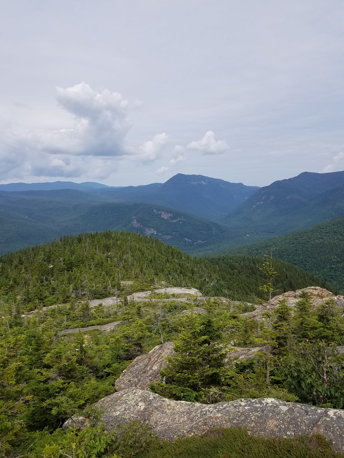
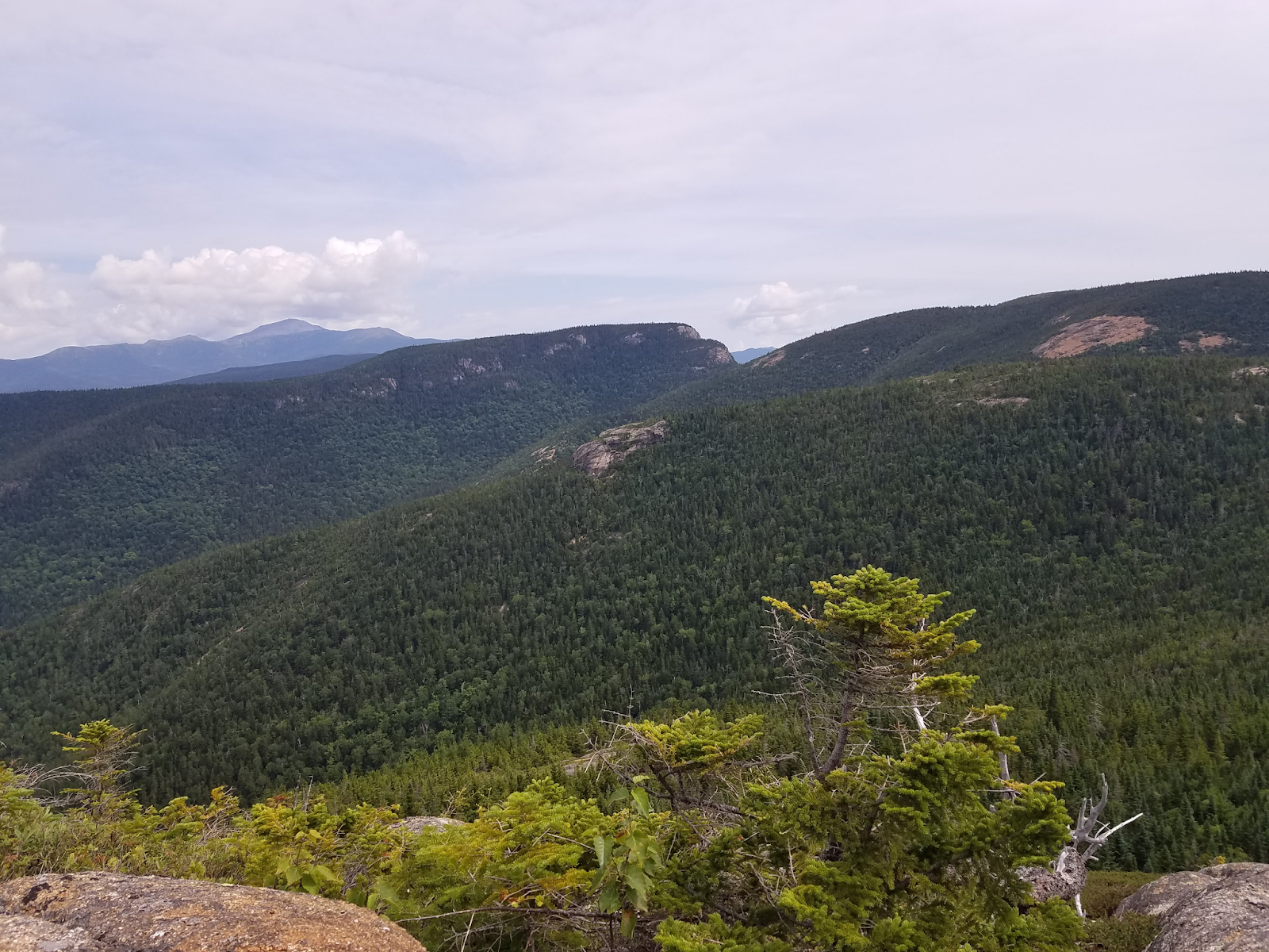
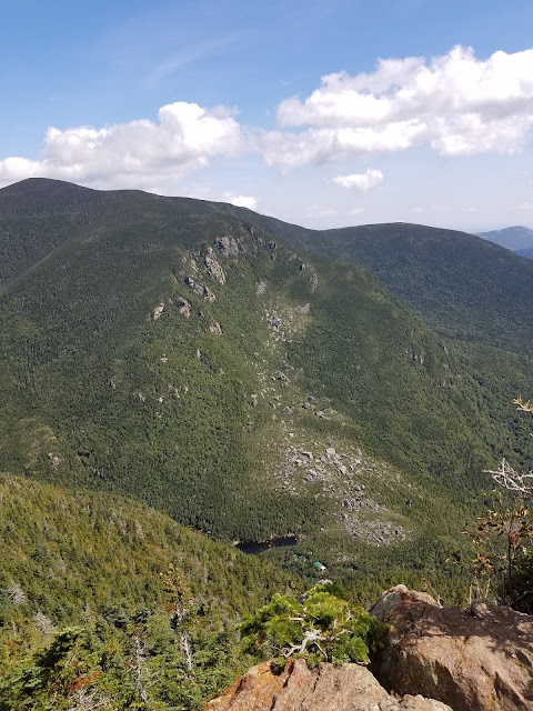
We were now entering unknown territory, since I'd only gotten this far last week. It turns out that the hike between Wildcat D and A is a series of up-and-down hill hikes. The trail is similar to the approach to Wildcat D - pretty rocky, but never as steep. It was a surprise when we reached Wildcat A; the hike took less time than expected. Someone was just leaving the summit as we approached, and we had the small outlook all to ourselves and the juncos as we ate our second pseudo-pepperoni sticks. We had a beautiful view of Carter Notch to the north. I think we were looking at Carter Dome to the east, and we could see a small number of buildings which must be where Carter Notch hut is located, below us.
Carter Notch

Carter Notch hut and Carter Dome in the distance (I think)
After enjoying the view and our far-too-dry snacks, we hiked on. The trail goes down steeply for about 0.7 miles, where it becomes more gradual and finally meets the intersection of the Carter-Moriah trail and the Nineteen Mile Brook trail. The Nineteen Mile Brook trail is not very exciting. It goes downhill at a very gentle grade, crossing little trickles of water that may give you more trouble at the beginning of the season, but were easily crossed now. The trickles of water did get wider as we got further down the trail, and eventually became so big that the trail maintainers felt they merited a footbridge.
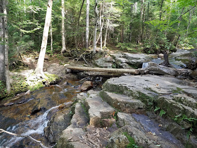
first footbridge along the Nineteen Mile Brook trail
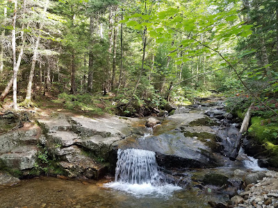
beautiful slabby brook with a cascade
The brook becomes pretty active and wide, to your left, once you pass the first footbridge. It's dotted with interesting slabby and blocky features.

Eventually, you come to a mysterious dam (who put the dam here, and why?), which creates a deep pool of water. The water is crystal clear, and on a day like today, it was tempting to take a dip. But we didn't have time. Around this point, a lightbulb went off over my head. I asked Maggie's boy: "Where are the keys to your car?" and he responded, "They're in your car, of course!" (he's in the habit of throwing the keys to the car in the cupholder). Oops!

I gave him my keys and urged him to hustle down the trail in the hopes of meeting the AMC shuttle. I was in no shape to hustle, as my right knee was bothering me, but he still felt fine. The Nineteen Mile Brook trailhead is a stop for the shuttle, but we had no idea what the schedule was. Foolishly, I had hopes that a bus pulled up every 30 minutes or so. It turned out that the shuttle stops at this trailhead 4 times a day... and he arrived at the trailhead about 20 minutes after the last stop, which happens to be 2:55 PM.

While he waited for me to arrive at the trailhead, he asked a couple of people in their cars for a lift to Pinkham Notch and was met with lukewarm refusals. No one was going that way, or they claimed they didn't know where Pinkham Notch was (it's about 5 miles down the road). If a strange man approached you for a ride, would you let them in your car? No! But when I arrived, seeing that he wasn't just a lone kook but was accompanied by a woman hiker, one driver relented, and Maggie's boy got a lift back to Pinkham Notch. For reasons that remain obscure, he felt he couldn't ask for a lift to Glen Ellis Falls, which is only one mile further. He ran down to Glen Ellis Falls, and then drove the car back to me, where our adventure ended.

Let this be a warning to you, people. If you are doing an end-to-end hike, do something to remind yourself to keep that second car key on your person. Literally attach it to your pack with a sling, if that's what it takes!

Monday, August 27, 2018

wildcat d

Today's hike: 5.8 mi | 5.5 h | 1.1 mph

The parking lot at Pinkham Notch was filling up when I arrived shortly after 8:00 am. I chose to hike in to the Wildcat Ridge Trail via the Lost Pond Trail. It adds about one hour to the hike, but it's easy, and it gives you an extended view of the scenic, clear Ellis River.

Wildcat Ridge Trail starts out steep and rocky, and stays that way for most of its length. There are rock scrambles like this one (not really as steep as it looks):
climbing up the Wildcat Ridge Trail
Your reward is a view like this:
Wildcat Ridge Trail view of Mt Washington
and this:
another view
The trail is well maintained. This is the first time in New Hampshire that I've seen wooden "stairs" set into the slabby rock to help you up.
wooden steps on the Wildcat Ridge Trail
Once you get up high enough, the trail becomes more moderate. At this point, I had some trouble deciding whether I'd reached the summit. I think that I hit "E" peak and wondered whether I was there. I didn't plan this trek very well, so I checked my map. The peak is supposed to be pretty close to where Wildcat ski area's gondola tops out, and I hadn't seen that yet, so I kept hiking... until I suddenly popped out into a clearing and saw this!
Wildcat gondola
The nerve of those people, taking a shortcut to the top! Actually, it turns out that this is not the top; you have to keep hiking for a short while, past these signs (familiar to me from my winter skiing adventures at Wildcat)...
Upper Polecat
... and on up into the woods for just a few minutes. Then you come to a raised platform which is at the real peak of the mountain.

I had a plan to possibly hike on to Wildcat A, but I was worried about the time required. I hadn't brought any food other than a single Vermont Smoke & Cure meat stick (which turned out to be yum!). I probably would have made it, but it seemed risky.

This is my 23rd 4000-footer! I'm getting closer to the halfway mark. It was another beautiful day in the Whites! It doesn't get much better than this.

PS: I really wouldn't want to do this one in the rain! The potential for slipping on wet rock would be bad.

Tuesday, July 31, 2018

mt crawford

Today's hike: 4.4 mi | 3 h | 1.5 mph

The plan was to hike Mt Carrigain via the Signal Ridge Trail. When we arrived at Sawyer River Rd, the forest road that you're supposed to take to get to the trailhead, it was barred. So - oops. It would take an extra 4 miles of hiking if we walked in to the trailhead, so instead, we opted to hike the Davis Path to Mt Crawford, an easier hike in the area.

The Davis Path is pretty much an uphill slog most of the way to the peak of Mt Crawford. It probably would be more fun in the fall, but today it was humid and tiring. However, the open slab at the top was worth the slog, rewarding us with numerous beautiful views.

view on the way to the summit of Mt Crawford

Gorgeous view of the railway in the valley, from the top of Mt Crawford

View looking north (I think) towards Mt Washington.

You can take the Davis Path all the way to the summit of Mt Washington, but we certainly weren't prepared to do that today. We turned back after checking out the views from Mt Crawford.

Monday, May 07, 2018

mt mexico

Today's hike: 5.6 mi | 3 h | 1.9 mph

Maggie's boy and I took the Big Rock Cave trail over Mt Mexico, to the Whitin Brook trail, and then returned on the Cabin trail, to make a big, triangular loop. The elevation gain is about 1500 ft.

Last year, we walked up to Mt Mexico with the intent of checking out Big Rock Cave. We got swarmed with mosquitoes along the trail. It was so bad that we turned around. In contrast, there were almost no bugs out today, although the trail was quite wet in many spots.

The hike up to Mt Mexico is a perfectly ordinary one with no interesting views. We did hear a very large racket from a bunch of peepers off in the distance, but didn't see them.

This hike is rewarding once you get beyond the "peak" of Mt Mexico, and reach the Big Rock Cave. This is a fun jumble of huge rocks that form a little cave. Looks like you could do some rock climbing here.
Big Rock Cave

Side of Big Rock Cave

A big rock
At Big Rock Cave, the trail turns sharply left and downhill. At this point, we could hear the roar of rushing water. We soon came to a wide, rushing stream crossing. Maggie's boy bounded across over some large rocks. I walked far uphill and took the less dignified way, skootching my way across on a huge downed tree.
Whitin Brook is difficult to cross right now
Good signage after crossing Whitin Brook

The joke was on me; we soon came to another stream crossing. In all, there were four crossings of the Whitin Brook, back and forth over it. The trail makers really wanted you to get a good look at this feature. On the third crossing, I gave up, removed my boots, and walked across barefoot. The water is cold, but refreshing.

Even after the last crossing of the brook, we encountered a lot of water along the trail. We passed a large vernal pool, but didn't see any frogs there.

Mt Paugus in the distance
The Whitin Brook trail becomes pretty steep as you approach the Cabin trail. This steep part of the trail takes you through an area where many trees have been downed, as if a giant overturned a box of toothpicks (the remnants of Hurricane Sandy, apparently). You get a few obscured views of Mt Paugus as you head up the hill. Interesting slab, but looks like lots of sandy, rotten rock too. That could be a fun hike, too.

Finally, we reached the Cabin trail. From there on, it was mostly a downhill hike over dry leaves.

It was a beautiful day for a hike! We had cool temperatures, and blue skies interspersed with soft milky clouds.

Tuesday, April 03, 2018

spring snow on the boulder loop trail

Today's hike: 2.8 mi | 1.3 h | 2.1 mph

I took the loop clockwise today. It was surprisingly busy. I passed a couple of people and got passed by someone doing a very good pace with a dog.

Trail conditions are still a bit rough. Down low, I could easily avoid any snow or ice. This is a view as I headed up the trail, approaching the first significant snow.

trail on the way to the overlook


As I neared the first outlook, I saw someone ahead of me who appeared to be having trouble on the icy trail. At this point, I stopped to put on my microspikes.

Soon after passing the view, trail conditions improved so much that I had to remove the microspikes. Then they got worse again heading under the trees, and I put them back on. That happened a few times. I didn't want to damage the points on my spikes, so I removed them when the trail cleared up much.

view at the top with the overhanging cliff at right


Hard to say how soon the snow will be gone. There's some mud, too, but it's minor. It's not looking like we'll have much of a mud season, currently.

a fall leaf embedded in the spring snow

Sunday, January 21, 2018

Mt Chocorua

Today's hike: 7.6 mi | 4.2 h | 1.8 mph

I hiked up the Champney Falls Trail off the Kanc to the top of Mt. Chocorua today, accompanied by a friend. This was my first hike in the Whites over a completely snow-covered trail, and it was probably as mild as it could be. The temperature at the parking lot was about 35 °F.

approach to summit of Mt Chocorua
The trail was completely covered in packed snow, so the going was very easy. I wore microspikes, which provided plenty of traction. I think it could probably be done bare-booted, but it would also probably be annoying and slow going.

Trail conditions are very good right now. There are just a few tricky bits. As you get into the switchbacks near the top, there are some short sections that are covered in thick ice. Also, once in a while I'd see a footstep where the snow had been completely scraped away to reveal a thick layer of glassy ice. None of this is a problem when using microspikes. With the forecast calling for rain this week, though, it wouldn't surprise me if the trail becomes much more slippery and difficult very soon.

The only slightly scary part occurs when you get to the top. Chocorua is very exposed, and I find it nerve-racking when the trail at the top goes clambering up and over some blocky rocks. It is definitely worth the effort, though!

view from top of Mt Chocorua to Carter Ledge
We got lucky today. It can be extremely windy at the top of Chocorua, which would make for a brutal windchill in the winter. However, there were just a few mild gusts at the top.

I just bought a brand new winter jacket at EMS, yesterday (yay, sale days!). I wore it on this trip. I only wore a long-sleeved shirt underneath, but even so, it turned out that I was overdressed. I hiked with my jacket unzipped for most of the trip, and even then I really felt too warm.

USGS survey marker at the top of Mt Chocorua
I ran into a bit of a problem about halfway up the trail. I started to feel some rubbing at the back of my left ankle, and I could tell that I was developing a blister. This happens to me a lot, far too often! Usually, I bring blister packs on my hikes, but I had forgotten to do so this time. I didn't want to turn around... I searched through my pack. I didn't have much extra stuff - a whistle, compass, emergency poncho in a mini-bag, etc. This was all packed into a plastic shopping bag from the grocery store. I thought about using the mini-bag that held the poncho as a makeshift bandage across my ankle, but was worried that it would shift around too much once I started moving again. My friend said "why not try the plastic bag?" Hm! I pulled off my boot and sock, and wrapped the bag around my foot and ankle, so the bag covered my foot starting from the arch and going all the way up my ankle. My friend helped me put the sock back on over the bag, which squeezed the bag in place. Then the boot went back on. It seems crazy, but this worked! I noticed that the bag stuck to my skin due to a bit of moisture, and it stopped the skin on my ankle from being rubbed directly. This might get too sweaty in the summer, but it was perfect for winter conditions.

This was my second hike to the top of Mt. Chocorua. I took the Liberty Trail last time. That approach to Chocorua seems steeper and more difficult than today's. The Champney Falls Trail has a mere 2,250 feet in elevation gain, as compared with the Liberty Trail's 2,700 foot gain.