Total miles: 56108. Trip miles: 407.4. Gallons: 8.650. Price per gallon: $3.799.
Screen mileage: 51.6 mpg. Tank mileage: 47.1 mpg.
Wednesday, June 29, 2011
Sunday, June 19, 2011
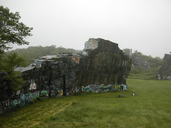
OJ


The first route I tried was OJ. It's the crack running straight up from the mat in the photo (at least I think that's OJ). It's a 5.5, but it took me several tries to get to the top. I felt a lot more hesitant without being tied in to a belayer, even though this route is not very difficult, and the mat was underneath me.
It was my first time bouldering at Hammond, and it's a lot of fun there.
Sunday, June 12, 2011
Tuesday, June 07, 2011
Tank one hundred and sixty-one
Total miles: 55700. Trip miles: 461.6. Gallons: 8.710. Price per gallon: $3.899.
Screen mileage: 54.0 mpg. Tank mileage: 53.0 mpg.
Short commutes and some longer drives too.
Screen mileage: 54.0 mpg. Tank mileage: 53.0 mpg.
Short commutes and some longer drives too.
Sunday, June 05, 2011
gray jay

When I stopped to finish my Clif bar at the Mt Willey cairn, I was accosted by a pair of gray jays.
I encouraged them by giving them a few crumbs of my bar. There are probably reasons you shouldn't do this, but I find gray jays very hard to resist.
At this point I felt pretty optimistic. I wasn't thrilled at the prospect of re-crossing Mt Field to get back to Crawford Depot, but my only other option was to travel south another 2.7 miles to Rt 302 via the Kedron Flume Trail, and then hike back north on the highway. This seemed unappealing, so I retraced my tracks to the Avalon Trail.
Things got dicey at the Avalon Trail. This trail is very typical for the Whites. It drops away beneath you unrelentingly for over a mile, and there are frequent encounters with steep rocky slides covered in running water that are difficult to navigate.
I'd been feeling fine up until this descent, which gave me quite a beating. By the time I got back to the car I was exhausted!
Despite that, this experience makes me think my training hikes don't have a huge benefit.
In all, this turned out to be a great start to the hiking season! The weather couldn't have been better, the bugs stayed away, and I hiked three of the 4000-footers in one day!
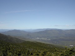
spectacular mt willey view
Once you reach Mt Willey, you are rewarded with a spectacular view to the east.
Unfortunately this spot was afflicted pretty badly with swarms of black flies. They didn't seem to be in feeding mode, but I kept the risk low and didn't linger here for very long.
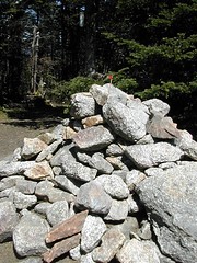
mt willey cairn
The trail from Mt Field to Mt Willey is more typical of approaches to the 4000-footers. As you leave Mt Field, you're faced with some steep, rocky bits, where you have to clamber down.
heading to mt field

Since I still felt great at Mt Tom, I decided to attempt Mt Field and Mt Willey. It made sense to get them all done, given the length of the drive.
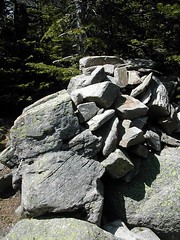
mt tom cairn
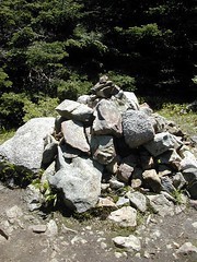
It took me 2 hours to get to the peak of Mt Tom. At this point, I was still feeling great! I had felt some hot spots developing on my heels, and stopped to slap on some blister treatment.
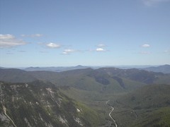
mt tom view
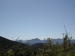
The hike to Mt Tom is relatively easy. Follow Avalon to the A-Z Trail, and then take the Mt Tom spur.
The views here are not great, but you can get a glimpse of some peaks in the distance.crawford depot
Yesterday, I continued my quest to hike all the NH 4000-footers. I went over Mt Tom (4051 ft), Mt Field (4340 ft), and Mt Willey (4285 ft). The total distance was 9.9 miles, done in 6 h 40 min (book time), for a pace of 1.5 mph.
I started from Crawford Depot. Here we have a view of the Depot from across the railroad tracks. It's not clear where the trail starts. If you park at the Depot, cross the tracks, and follow an unmarked trail, in just a minute you will come to a very clear sign indicating the start of the Avalon Trail.
I had decided on Mt Tom because I hadn't done any training hikes, and it looked like it could be one of the easier 4000-footers to get to: 2.8 miles to the top, about 2400 ft of elevation change. I had also noted that Mt Field and Mt Willey were in the neighborhood, so I could attempt those if I were feeling strong.
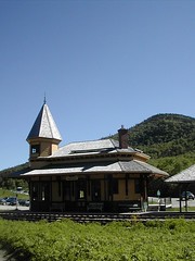
Subscribe to:
Posts (Atom)