This photo shows how many matches it took to get that candle going... It also depicts the luscious innards of a Hostess cupcake, in the midst of fulfilling its sacrificial destiny. Although my palate has become fairly sophisticated, I still find the Hostess cupcake to be a delicious treat, if taken only once a year. Let that be a warning to parents about what to feed their kids. You never know what they'll fixate on.
The only thing missing here is the Birthday Latte. But that's more a tradition for the Birthday Breakfast, and this year it was an evening celebration.
Monday, July 31, 2006
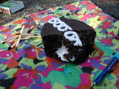
Happy Birthday to you...
The weather was perfect, except for the slight breeze that kept kicking up just when I'd strike a match to light the candle. With the heat we've been having, I shouldn't have been cursing a breeze, but it made it devilishly hard to keep the candle lit. Lit, of course, the candle must remain, for the entirety of the performance of the "Happy Birthday" song - a crucial part of the birthday ritual.
Eventually I gave up and moved the picnic to a more sheltered area nearby, which lacked the nice view. Even there, I had difficulty keeping the candle lit. But it finally worked - as evidenced in this photo.
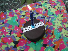
Eventually I gave up and moved the picnic to a more sheltered area nearby, which lacked the nice view. Even there, I had difficulty keeping the candle lit. But it finally worked - as evidenced in this photo.
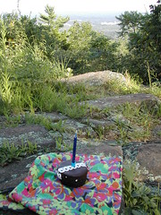
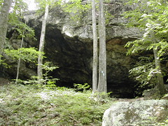
Hezekiah's Knob
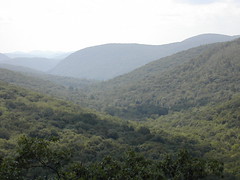
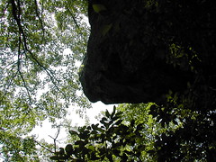
Today being July 31, I hiked up to a "high place" for the traditional celebration of the birthday of a good friend, in absentia. I picked Hezekiah's Knob, off the blue trail at Sleeping Giant. This photo gives you a cupcake's-eye view of some industrial area off to the south - if you stand up, you get more of a panorama. Alas, the cupcake does not have the good fortune to be able to stand up; sitting is pretty much all it does. I did hold it up to give it a good look at the scenery. That was the least I could do, as it was soon to meet its demise.
Sunday, July 30, 2006
Macedonia
On Sunday, I hiked the Macedonia Ridge Trail, which is a loop 6.7 miles in length. It took me 3.5 hours to complete it, a pace much slower than yesterday's.
I found this trail fairly difficult. I was carrying a backpack, which weighs more than my daypack, which didn't help. The heat and humidity were as oppressive as on Saturday, with rare cool breezes. And maybe I was a little worn out from my Tunxis hike.
This is the view from Cobble Mountain, which is about two miles from where I started my hike. Supposedly those are the Catskills out there, somewhere.
The trail up to Cobble Mountain was so steep and rocky that I had to use my hands to crawl up parts of it. At one point there was a slab of rock where I had to pull myself up using just my arms. Ordinarily I enjoy this kind of thing, but not when wearing a pack. At some point I was thinking about how they'd find my body at the foot of the cliff, and what a shame that my organs would all be far too rotten for donation by the time they'd found my body.
Anyway, I made it up alive, but it kind of wiped me out. That was at mile two, and I still had almost five miles to go, with many more ascents! I was a zombie by the time I got back to the car - just putting one foot in front of the other. I could really use a break from this brutal weather we've been having.
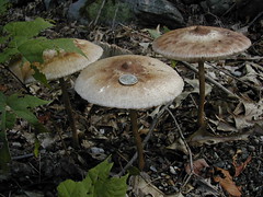
Toadstools
These large fungal specimens had sprouted in the yard of the home where I stayed this weekend. I placed a US quarter on the middle one for scale; it easily handled the weight.
They looked edible, potentially yummy, but I bet I'd have been vomiting up my guts if I'd tried one...
They looked edible, potentially yummy, but I bet I'd have been vomiting up my guts if I'd tried one...
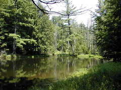
Ratlum Brook camp area
This is a great spot, at 2.9 miles in. I should have brought my swimsuit. As it was, the spot had a nice breeze and was remarkably free of bugs. I stopped to eat lunch here - there's even a picnic bench.
According to the Walk Book, this Northern Region of the Tunxis Trail is "one of the steepest, most remote, and least used of the system." I won't vouch for steepest or most remote, but it sure was quiet. I didn't see a soul the entire hike.
According to the Walk Book, this Northern Region of the Tunxis Trail is "one of the steepest, most remote, and least used of the system." I won't vouch for steepest or most remote, but it sure was quiet. I didn't see a soul the entire hike.
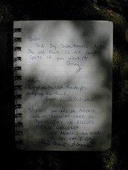
Little Brook register
This is the first page of the Little Brook register on the Tunxis. The first entry - a mixture of the mundane with the tragic - is from September 11, 2001.
Tunxis
This weekend I went hiking in the northwest corner of CT. On Saturday, I hiked part of the Tunxis.
My plan was to do a long hike, but I got started late, and wound up at the trail around noon. It was hot and humid, really beastly - sweat was running down my face and body, which meant that it was not doing a very good job of evaporative cooling. I decided to chuck my plans and leave the trail early.
I wound up doing 6.2 miles, if I believe the Connecticut Walk Book. But that just doesn't seem right, because I timed it at 2 h 10 minutes, which would have me doing almost 3 mph, an unusually fast pace (the trail was not easy). It's a mystery.
Wednesday, July 26, 2006
A review of "Girl in Landscape: A Novel (Vintage Contemporaries)"

by Jonathan Lethem
I became a fan of Jonathan Lethem after I read his powerful and disturbing short story, “The Happy Man”, in the February 1991 issue of Isaac Asimov’s Science Fiction Magazine. From then on, I’ve kept an eye out for his work. He’s never done anything quite so good as “The Happy Man”, IMHO, but he’s an excellent writer, well worth reading.
"Girl in Landscape" is an absorbing novel; every time I picked it up, I got sucked right in. With uncomplicated prose, Lethem evokes strong, disturbing moods – alienation chief among them. He easily delves into the mind of his protagonist and puts everything there on view, in a very interesting way.
My only disappointment with this novel, alas, is the end. This is not to say that the ending was bad; it’s just that I was hoping for something really really good, and this was just ok. Still, this is well worth the read – a fascinating work.
I compare this novel favorably to Donna Tartt’s "The Little Friend", a good novel whose ending also disappointed me just a bit. Similar characters, similar moods, feelings of disconnection and alienation in a bizarre environment, etc.
Sunday, July 23, 2006
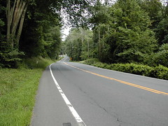
Route 68
A word about the Mattabesett where it intersects Route 68: the trail is poorly blazed here, so it is hard to see where the trail turns off to the north, unless you are constantly on the lookout. I didn't see any blazes marking this turn.
This is a view looking down at the parking area in the distance, as you come out of the trail onto Route 68. It's about a 3-minute walk along Route 68 between the parking area and the turn-off going north into the woods. Or, more accurately, a 3-minute dance with death. The shoulder along Route 68 becomes frighteningly narrow in places - less than a foot wide - and traffic travels at about 50 mph along the road. When you're walking in the direction of traffic, it's particularly nasty. This is one of the reasons that I rarely hike here.
If you leave the parking area, and, after walking for a few minutes you come to the beginning of a guard rail, you've come too far. Keep an eye out for the turn-off to your right soon after you've passed the very narrow part of the shoulder.
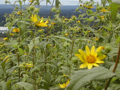
Helianthus
There was a big field of these tall yellow flowers just in front of the ridge. I think these are Helianthus divaricatus (woodland sunflower). I'm going by the shape of the leaf as well as the flower itself. There are many plants that have a similar flower, so it's hard to tell.
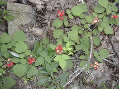
Black raspberries
When I took this trail on August 7 of last year, the black raspberries were at their peak. It's only July 23, and I'd say they are a little beyond their peak now. Still some very tasty ones to be had, though!
I am pretty sure these are black raspberries; I saw just a few that had turned black. I tried them but they were not as tasty as when they're red - kind of seedy and more sour when black. I wonder if the birds like them that way.
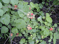
I am pretty sure these are black raspberries; I saw just a few that had turned black. I tried them but they were not as tasty as when they're red - kind of seedy and more sour when black. I wonder if the birds like them that way.
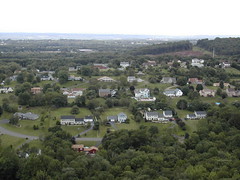
McMansions
I posted a photo of this view last August. There is new development work going on this year - notice the large swath of fresh earth where the forest has been cut back in the upper right corner of the photo. Will the trees all be gone some day?
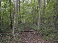
Beseck Ridge section
I did a four-hour hike today, about eight miles. This is the same trail that I did on August 7, 2005, only I didn't complete the entire section.
It was a cloudy day, and a smattering of rain came down on my way to the trail, but otherwise the rain held off. It turned out to be a good day for a hike, finally - a nice cool breeze was blowing most of the time.
This section of the Mattabesett must just be unusually buggy. Similar to last August, I was plagued by deer flies, picked up a few ticks (lots of tall grass), and blundered through several micrathena webs (which is more or less a room 101 experience).
Saturday, July 22, 2006
The Large, the Small, and the Human Mind
I finished "The Large, the Small and the Human Mind", by Roger Penrose. This has been on my shelf for quite some time because it was rather daunting, and I wanted to pay it proper attention.
It is not an easy read, but it’s worth the effort. It has refreshed my interest in physics.
See more progress on: Read one book a month
Raspberries... or maybe black raspberries
These berries have neither the taste nor the texture of domesticated red raspberries, so they're either quite different in the wild, or they are in fact not red raspberries. They could be black raspberries, although at the moment none of them are black. I suppose they might eventually become black, if anyone could resist eating them from the vine (excuse me, I guess I should say "cane") before they got to that state.
These were growing right alongside the trail. Lovely and delicious. I guess I got more than my share of anthocyanins today, since I've eaten cherries and red grapes in addition to these berries.
These were growing right alongside the trail. Lovely and delicious. I guess I got more than my share of anthocyanins today, since I've eaten cherries and red grapes in addition to these berries.
Looks like rain
And it did, about 40 minutes into my hike. A steady downpour. I popped on my Helly Hansen rain jacket and did an immediate about-face. After about two minutes, the rain stopped. But I headed back anyway. The rain continued on and off... I don't mind hiking in the rain, but I was not in the mood for it today. Real crappy weather we've been having this summer!
Sunday, July 16, 2006
Millers Pond
This section of the Mattabesett winds around Millers Pond in Millers Pond State Park. If I had known this pond was open to swimming, I might have brought my swimsuit with me. The heat was oppressive, and as it was, I was tempted to jump in with my clothes on.
It was pretty crowded, and the trail does wind its way through some of the bathing areas. Not the most peaceful wilderness experience!
Directly after taking this photo, my camera's battery, which lacked my stamina, was "exhausted."
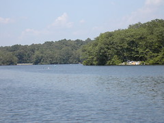
It was pretty crowded, and the trail does wind its way through some of the bathing areas. Not the most peaceful wilderness experience!
Directly after taking this photo, my camera's battery, which lacked my stamina, was "exhausted."
View from Bear Rock
This is the view from atop Bear Rock. It was pretty hazy and blistering hot. Not the best day for hiking, but you have to take what you can get.
You can barely see the church spire in Durham, to the left a bit, down near the tree line.
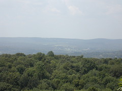
You can barely see the church spire in Durham, to the left a bit, down near the tree line.
Bear Rock
I hiked the Mattabesett section from Higganum Rd to Wiese Albert Road today: a 6-mile round trip in 2 hours and 35 minutes for a pace of 2.3 mph. Not bad, for a hot and humid day. I was not especially strong; rather, this section of the trail is not especially challenging. It's mostly flat. Any gradients are rarely steep, and when they are, they're short.
I should mention that there is good parking on the shoulder of Higganum Rd near the trail crossing, although the trail map doesn't mention it. I see no advantage to parking on Harvey Rd at the official parking area.
This photo is taken from beneath Bear Rock, as it overhangs the trail. The rock does look a bit like a bear's head in profile. Bear Rock is one of the few steep crawls along the trail. You can avoid the crawl via a bypass trail, if desired.
Looking at more charities
I get lots of solicitations in the mail from charitable organizations. Usually I toss them, but recently I got something from FINCA, a micro-lending non-profit, that caught my eye. After reading their material, I put them on my list for further investigation for my end-of-the-year giving. I'm also thinking about National Resources Defense Council. Both get a reasonable score from Charity Navigator.
I finally signed up with Charity Navigator, because you can maintain your personalized list of charities there. It does concern me that Charity Navigator does not evaluate itself, but they give a plausible reason for not doing so. I am curious about how much the president, Trent Stamp, pays himself. When I review a charity my eye automatically goes to the director's compensation. I get irked when I see a non-profit director being paid more than me. I then have to weigh my level of irked-ness with my fondness for the charity.
I do read Trent Stamp's blog on occasion. His rants can be quite amusing! Hard not to like and trust the guy.
Sunday, July 09, 2006
Words that begin with "ch"
I took a short hike today, and inexplicably became obsessed with the number of French words that I know which start with "ch". These are the ones I could come up with off the top of my head:
- chacun - each
- chaise - seat/chair
- chalet - chalet
- champagne - champagne
- champignon - mushroom
- chance - luck
- chanteuse - singer (f)
- chapitre - chapter
- chaque - each
- charme - charm
- chauffeur - driver
- chaussure - shoe
- chemin - road (e.g. chemin de fer - railroad)
- cheval - horse
- chèvre - goat
- chien - dog
- chiffre - cipher (as in code) or number
- choc - shock
- chocolat - chocolate/hot chocolate
- chômeur - unemployed
- chose - thing (or something)
OK Computer
My Sony Vaio died two weeks ago. It was a slow process, and I was able to try some fixes (in no particular order):
I got my new machine, a Dell, on Friday. It's OK. I'm slowly getting my old software installed: Firefox, AT&T Worldnet software, MS Office, MS Money...
The new machine came with a get-six-months-free offer from Earthlink, so I decided to try it. It kind of sucks - their toolbar seems to be screwing with Microsoft's Data Execution Protection (DEP), which causes the system to hang unpredictably. I think it's their toolbar, I'm not completely sure; DEP seems to be messing with a number of applications (which makes me miss Win 98). In comparison, my old AT&T Worldnet service seems to be performing without a glitch, so I'll probably drop Earthlink soon.
I'm incredibly lucky in having backed up most of the stuff on my old hard drive just one week before it died! Am I psychic?! As I'm starting afresh, I've realized that I missed a few things: my browser bookmarks and history, and stuff I'd been keeping on the Desktop. I wonder what else got left behind?
- fdisk /mbr
- scandisk
- Maxtor PowerMax utility, which consistently said everything was fine
- replacing the CPU fan
- Running Norton Antivirus on the hard drive, from a CD-ROM
I got my new machine, a Dell, on Friday. It's OK. I'm slowly getting my old software installed: Firefox, AT&T Worldnet software, MS Office, MS Money...
The new machine came with a get-six-months-free offer from Earthlink, so I decided to try it. It kind of sucks - their toolbar seems to be screwing with Microsoft's Data Execution Protection (DEP), which causes the system to hang unpredictably. I think it's their toolbar, I'm not completely sure; DEP seems to be messing with a number of applications (which makes me miss Win 98). In comparison, my old AT&T Worldnet service seems to be performing without a glitch, so I'll probably drop Earthlink soon.
I'm incredibly lucky in having backed up most of the stuff on my old hard drive just one week before it died! Am I psychic?! As I'm starting afresh, I've realized that I missed a few things: my browser bookmarks and history, and stuff I'd been keeping on the Desktop. I wonder what else got left behind?
Saturday, July 08, 2006
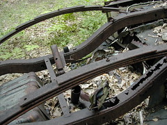
Leaf springs
I love this wreck. Rarely do you get to see a car's innards so clearly. Check out these leaf springs - cool!
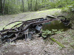
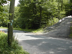
Car wreck
I didn't notice when the trail took a sharp right turn, and kept walking along an unmarked trail, which led up to this old auto wreck, where several trails intersected. It was here that I noticed the lack of blue blazes; fortunately not too far from the turn off. This is getting close to Higganum Road.
Relocation
This notice is posted just below Coginchaug Cave. "From this point, the Mattabesett Trail has been relocated to circumvent a new housing subdivision. From here, the trail turns generally south, then east, reaching a high point at a state forest boundary in 1/2 mile. From there the trail continues in an easterly direction, and then more northerly, rejoining the old trail in another 1/2 mile. From here, it is 1.6 miles to Higganum Road. The relocation adds 0.8 mile. Connecticut Forest and Park Association 1/20/05".
I'm happy to get the extra miles added to the trail, but I have to wonder if the total woodland area has decreased in this area due to the new subdivision.
I took the side trail up to Pine Knob Overlook, which used to be where the main trail went. I haven't been on this section of the trail since the relocation occurred; I think I was up here last in 2004.
Parking notice
This is a closeup of the sign near the trailhead directly off Old Blue Hills Rd. The top sign says "NOTICE TO HIKERS Please park on grassy area - Do not park at curb on street. Thank you - C.F.P.A". So yeah, you can park here.
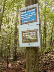
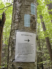
Trailhead
Here is the entrance of the Mattabesett Trail into the woods off Old Blue Hills Rd. Two signs mark it. That's my little daypack beside the curb.
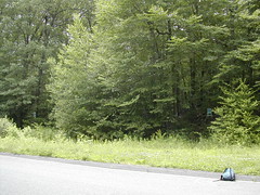
Misleading
I hiked the Coginchaug Cave section of the Mattabesett Trail today - about 6 miles in 3 hours.
I parked on Pisgah Rd, near the intersection of Sand Hill Rd and Rte 79. I crossed Rte 79 on foot, following Old Blue Hills Rd to this point, where the blue blazes indicate a right turn. I was doubtful, but I followed the road to the right. That was a mistake; I couldn't see any more blue blazes, and the road quickly led to a cell tower. I came back down and found the real trailhead to the right, a few hundred feet beyond this turnoff.
I parked on Pisgah Rd, near the intersection of Sand Hill Rd and Rte 79. I crossed Rte 79 on foot, following Old Blue Hills Rd to this point, where the blue blazes indicate a right turn. I was doubtful, but I followed the road to the right. That was a mistake; I couldn't see any more blue blazes, and the road quickly led to a cell tower. I came back down and found the real trailhead to the right, a few hundred feet beyond this turnoff.
Wednesday, July 05, 2006
First tick bite of the season
I went for a hike yesterday, covering 9.5 miles in 4 hours and 10 minutes, for a pace of about 2.3 mph. This is pretty good, considering that the weather was beastly: hot and humid. I did the Mattabesett-Lone Pine Trail loop. When I got home I discovered a deer tick attached to the back of my left calf. It was easily removed, probably got it before Lyme infection could occur.
Subscribe to:
Posts (Atom)