view from watatic
Originally uploaded by wereldmuis.
Yesterday's hike: 5 h 0 min | 10 mi | 2 mph
Mileage is approximate, and I'm probably overestimating; I didn't have a trail map. I did a section of the Midstate and connected with the Wapack, carrying a pack that weighed 14 lbs to start.
I began at the Ashburnham State Forest parking lot, which was pretty crowded. The hike over Watatic to the NH state line is supposed to be 1.06 miles, according to the trail guide. It always takes me an hour. It was 38 minutes from the parking lot to the summit, which is about 400 feet or so uphill, and I'm nearly certain that's how long it took me last year. This year I was much more fresh, but I was also taking my time.
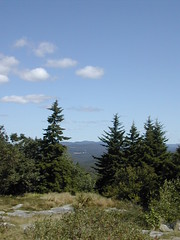
This is a view from the top of Watatic. I looked around, but I could not find the geodetic survey marker that I found last year. Very strange. There were a few people up there, so I didn't stay long.
No comments:
Post a Comment