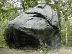
Sunday, September 30, 2007

View from the Metacomet


View from the Metacomet
Originally uploaded by wereldmuis.


My sister and I went hiking on the Hanging Hills section of the Metacomet today. I am mortified to admit that we got lost, and were saved by a charming and gallant gentleman who drove us back to where our cars were parked. Chivalry is not dead.

Monday, September 24, 2007

Tank twenty-two

Total miles: 8769. Trip miles: 479.9. Gallons: 8.355. Price per gallon: $2.859.

Screen mileage: 58.7 mpg. Tank mileage: 57.4 mpg. About a week of 45-min RT commutes on this tank, plus a long 3-hour RT at highway speeds. Excellent mileage!

I tanked up at the usual pump, this morning.

Sunday, September 23, 2007

Black Bear Hollow Cafe - the Westkill


Black Bear Hollow Cafe - the Westkill
Originally uploaded by wereldmuis.


This is the "Westkill": scrambled eggs, cheddar cheese, and sausage, all wrapped lovingly in a flour tortilla. I got it at the Black Bear Hollow Cafe in Phoenicia, NY, after coming down from Panther Mountain this morning. Of course, I got another latte as well. Both were astoundingly delicious and satisfying!

It was a great trip, altogether! I did forget to bring some items (a flashlight would have been useful but I did without it OK). Doing a backpacking trip like this without much planning is always a risk, but the internet makes it possible... thanks to Catskill Hiker for providing the info that was so useful.

Black Bear Hollow Cafe


Black Bear Hollow Cafe
Originally uploaded by wereldmuis.


The Black Bear Hollow Cafe has a small windmill in front of it. If you do a hike of Panther Mountain, you should really stop in here. Your tastebuds will thank you!

Fox Hollow parking lot sign


Fox Hollow parking lot sign
Originally uploaded by wereldmuis.


This is the sign to the Fox Hollow trailhead parking lot, off Fox Hollow Rd, south of Rt 28, between Allaben and Shandaken, so well described by Catskill Hiker.

The sign says it is 4.9 miles to the summit. It took me about 3.3 hours of hiking to reach the summit, putting my pace at about 1.5 mph. Not bad. My pack weighed about 20 pounds without water.

On the way back down my pace was faster, almost 2 mph. Without poles!

View on the way down from Panther Mountain


morning view
Originally uploaded by wereldmuis.


There are no really excellent views on the Fox Hollow Trail until you get to the summit; even at the summit, the view is only so-so. This is one of the best, at a small lookout on the way.

tent


tent
Originally uploaded by wereldmuis.


Around 6 pm I decided that it was likely that no one else would come and interfere with the peace at my chosen site. So I set up my tent. I left the fly open, thinking it probably would not rain.

I did get to watch the sky turn dark through the mesh roof of my tent. But soon after, a light sprinkle of precipitation hit the mesh, and I scurried to close the fly, trying to avoid getting my sleeping bag wet. I fastened the fly with only one peg. Almost immediately, a drenching rain came down. I was a little worried, but the fly held up fine.

As usual, I neglected to bring enough sleepwear and my toes got kind of frosty. By morning, the clouds had cleared up, bringing a brighter, colder, drier day. Once I packed up and got moving, I warmed up pretty quickly.

reading at the campsite


reading at the campsite
Originally uploaded by wereldmuis.


After reaching the summit of Panther Mountain, I turned back and settled into a small makeshift campground slightly below 3500 feet. I had brought along Amy Chua's "World on Fire", and finished a good chunk of the book before it was time to set up my tent.

The book is not good campground reading because it deals with some particularly gruesome subjects. However, I needed to make headway in the book since it's due back at the library this week.

View from Panther Mountain


view from Panther Mountain
Originally uploaded by wereldmuis.

Panther Mountain


Panther Mountain
Originally uploaded by wereldmuis.


I made it to the summit! This little slip of paper left behind by some other hikers proves it.

3500 feet


3500 feet
Originally uploaded by wereldmuis.


Once I got to 3500 feet, I stashed my backpack off to one side of the trail. No use packing it up since you can't camp above that elevation. Good thing, too. The trail gets steeper in spots from then on, and the air was full of moisture that was condensing on the rock scrambles, making the going quite slippery.

red leaves


red leaves
Originally uploaded by wereldmuis.


This is a view looking down a cliff wall at a red-leafed maple, stretching up for the light.

red leaves, blue trail marker


red leaves, blue trail marker
Originally uploaded by wereldmuis.


There are some maple trees turning red up on a rocky "false summit" on the way to Panther Mountain. This red-leaved tree is host to a blue trail marker as well.

Catskill Hiker says

The trail is not very well used and would be hard to follow except for the blue trial markers.

That may have been true at the time, but right now the blue trail markers are practically not necessary. It seems that the trail has been maintained recently. There are still lots of brambles that cross the trail, in spots, and I've got the scratches on my arms and legs to prove it. It could be better, but it's not so bad.

magic latte


magic latte
Originally uploaded by wereldmuis.


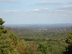
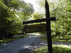
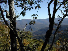
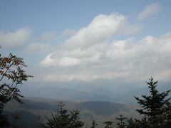
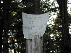
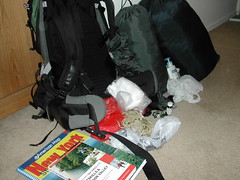
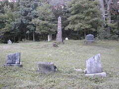
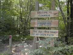
For my trip to the Catskills, I had decided to take the hike up Panther Mountain, described by Catskill Hiker. This is the first time that I've planned a trip based entirely on an internet description. So I went to my local Barnes & Noble, hoping to pick up some trail maps, in case I encountered difficulties (parking lot too crowded, missing, or whatever). The closest I could get was a book of day hikes in the Catskills. I figured at least one of those hikes would work for me, if Panther Mountain did not.

On impulse, I also picked up Greenspan's new memoir, "The Age of Turbulence", unabridged, in CD format. Good thing! I'm enjoying it a great deal. I finished three of the sixteen discs on the drive to and from the Catskills.

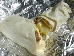
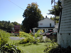
Once I got to the vicinity of the trailhead, I began scouting around for a spot to pick up extra water. I had realized, belatedly, that I had not checked to be sure that there would be a water source somewhere along the trail. I spotted something that was too tempting to pass up - a cafe! This was the Black Bear Hollow Cafe. It is to the south of Rt 28, near Phoenicia, NY. They had breakfast sandwiches and - gasp - lattes! I got a "Highmount" (bacon, scrambled egg, cheddar cheese on a hard roll) with a latte. It was utterly delicious.

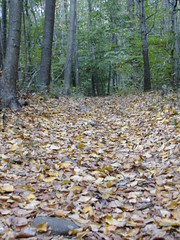
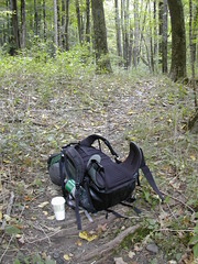
By the time I reached the trailhead, I had barely touched my latte, so I brought it with me. I think it was this magical latte that made my hike up the mountain less difficult than usual. I haven't been backpacking in two years, yet I felt very strong and my feet were light on the hike up.

Friday, September 21, 2007

Backpacking


Backpacking weekend
Originally uploaded by wereldmuis.


Sunscreen, potable aqua, compass, bear bag.... what am I missing?

Wednesday, September 19, 2007

Tank twenty-one

Total miles: 8289. Trip miles: 402.5. Gallons: 7.686. Price per gallon: $2.819.

Screen mileage: 54.6 mpg. Tank mileage: 52.4 mpg. Trips are mostly suburban driving for about 45 minutes.

I tanked up at the usual pump, early this morning.

Sunday, September 16, 2007

Too early for fall


Too early for fall
Originally uploaded by wereldmuis.


I went hiking at Alice Newton Street Memorial Park today. The leaves are really coming down there. It's happened all too quickly, it's only the middle of September!

Thursday, September 13, 2007

gravestone


gravestone
Originally uploaded by wereldmuis.


A gravestone in the ruined graveyard off the Woodtick Trail in Wolcott.

The gravestone reads
"In memory of Eunice
wife of
?uar Brocke
who died
March 11, 1833
AE.t. 81."

That is a long time ago.

Stele


stele
Originally uploaded by wereldmuis.


This is a closeup view of the stele in the graveyard off the Woodtick Trail. The engraving is partially obscured. It reads:

"Wiard
Seth Wiard
Died July 4 1870
AE. 60.
Jennette B. Co?es
??
Died ??"

Cemetery


gravestones
Originally uploaded by wereldmuis.


This evening I finally got the opportunity to take a hike along the Woodtick Trail, in Wolcott. I have been trying for the past week or so, but I could never find enough time, or a good parking spot.

The Connecticut Walk Book lists the Woodtick Trail as a side trail to the Southington section of the Tunxis Trail. The map in the book indicates that there is parking at the trailhead off Woodtick Rd, and the description says "Very limited roadside parking". "Very limited" is putting it lightly - in fact there is practically no parking at all. I actually did not park north of the powerlines as suggested in the book, but just south of them, to the west of Woodtick Rd. There is a very small dirt pull-off there. The unpaved ground beyond the road has eroded, so if you're not careful, you can get stuck by parking here. I pulled out in reverse to avoid that situation.

You can access the Woodtick Trail via the powerline trail, or walk a little further north along the road to get to the trailhead. This is not a spectacular trail; it seems to be used by dirt bikes quite a lot. I only saw tracks of dirt bikes on the trail, no sign of boot prints at all. The trail is loose and gravelly for as far as I took it, which is not far.

Following the trail, you very quickly come to this ruined cemetery. I was filled with sadness as I walked through this graveyard tonight. I think it was the sign of all these ruined headstones, perhaps vandalized or maybe only aged. The dates on the graves are as old as the early 1800's. It was somehow painful to think about those people long dead.

Despite the ruination, the graveyard is not abandoned. I saw a few little flags planted around some headstones, and one very new, large tombstone - but still with dates from the 1800's.

Tuesday, September 11, 2007

Tank twenty

Total miles: 7886. Trip miles: 422.0. Gallons: 7.409. Price per gallon: $2.859.

Screen mileage: 57.4 mpg. Tank mileage: 57.0 mpg. Trips on this tank have been mostly 45 minutes at 30 to 50 mph, like last time. I did two longer highway trips, about 1.5 hours each way.

I tanked up at the usual pump, again, this morning.

Sunday, September 09, 2007

Cairn


Cairn
Originally uploaded by wereldmuis.


This is the cairn at Elderslie Preserve. From the trail, you can't tell that it is U-shaped. I wonder how old it is?

This is not the first time I've seen elaborate cairns in the New England woods. I used to think they were built by boy scouts as little engineering projects, but after reading some pages at the NEARA site, I'm not so sure. I don't know what to make of NEARA, whether to take them seriously or not. I'm not the only one to be intrigued by cairns.

Damaged letterbox


Damaged letterbox
Originally uploaded by wereldmuis.


Last weekend, I went letterboxing at Elderslie Preserve. The last box that I went searching for was called "Triple Fork". I discovered it easily. It had been damaged - the box had a crack in the bottom of it, allowing moisture to seep in. Apparently this happened months ago, judging from a comment left by the last boxer to stamp in. That boxer had rebagged everything in the box, which was nice. Unfortunately, when I found it, the logbook was practically dripping wet, sealed away in its bag. Everything else in the box was pretty dry, so I took the logbook home to dry it out thoroughly. I returned the log today, and replaced this split box with a brand new one.

Wednesday, September 05, 2007

Tank nineteen

Total miles: 7464. Trip miles: 448.6. Gallons: 8.101. Price per gallon: $2.849.

Screen mileage: 56.4 mpg. Tank mileage: 55.3 mpg. Trips on this tank have been mostly 45 minutes at 30 to 50 mph, like last time. I tanked up at the usual pump this morning.

Monday, September 03, 2007

Colonial foundation at Elderslie Preserve


colonial foundation at Elderslie
Originally uploaded by wereldmuis.

glacial erratic


glacial erratic
Originally uploaded by wereldmuis.


This glacial erratic is directly on the blue trail, at Elderslie Preserve.

Elderslie Preserve


Elderslie
Originally uploaded by wereldmuis.


The weather has been very cooperative this Labor Day weekend, and I've been able to get out every day.

Today, I went hiking (and letterboxing) in Elderslie Preserve (PDF trail map). It's not just the usual nature preserve, but has some old colonial ruins and a few glacial erratics. There's supposed to be a cairn on the property, as well, but I didn't have time to look for it.